What If the Ice Ages Had Been a Bit Less Icy?
Steven Dutch, Professor Emeritus, Natural and Applied Sciences, University of Wisconsin - Green Bay
If the world's a stage, geology builds the sets. We could speculate endlessly on what might have happened if the dinosaurs hadn't become extinct or if the continents had broken up differently than they did. If the continents had moved just a bit more slowly, Africa would not yet have collided with Eurasia. There would still be an open seaway connecting the Mediterranean with the Indian Ocean and Columbus wouldn't have had to try sailing west. We also would not have oil in the Middle East. We can play any games we like with speculations like these. I was once contacted by someone who was planning to write a science fiction story set a billion years in the future, and wanted to know what possible configurations the continents might have. I told him that in a billion years there would probably be several cycles of assembly into supercontinents followed by fragmentation, and he was free to postulate just about any configuration of continents he liked.
On the other hand, the most recent ice age ended just before the start of recorded history and the ice advances profoundly reshaped the earth's surface. Here we can make some informed speculations about how the world might have been very different if the ice ages had been just a bit less icy.
Northern Hemisphere Ice Sheets

Ice caps in North America and Europe are well documented. The ice removed water from the sea, lowering sea level by up to 100 meters. Large areas of the continental shelves were exposed. Most of the ice north of Siberia accumulated on what is now the shelf and the extent of Siberian ice is poorly known. Lowering of sea level also exposed the Bering Strait land bridge.
Glacial Deposits and Landforms in the Continental United States
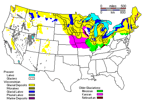
In the continental United States, four main ice advances are recognized. Why only four? With average intervals of 100,000 years, there was time enough for 20 to 25 ice advances since the Pleistocene began about 2.5 million years ago. It's possible that the Nebraskan ice advance might actually incorporate several events, and that other events have been completely obliterated or buried by later advances.
On the other hand, there are geologists who suspect that the earlier advances might have been less extensive and restricted mostly to Canada. So let's imagine that the ice ages were a bit less icy and never deeply invaded the continental United States, or blocked the St. Lawrence River for extended periods.
Ice Diversion of Rivers in North America
Ice Diversion of the Missouri River
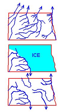 |
Top: The Missouri River
did not exist in its present form before the Pleistocene.
At that time, the largest drainage in North America
flowed northeast to Hudson's Bay. This map shows the
buried pre-Pleistocene valleys in North Dakota,
identified by well drilling. Middle: During the Pleistocene, about 2/3 of North Dakota was ice-covered. Water flowed along the ice margins to the south. This is called an ice-marginal drainage. Bottom: The ice-marginal drainage remains as the present Missouri River. Many of the other present rivers of North Dakota are also ice-marginal drainages. Only a few of the pre-Pleistocene valleys were re-occupied after the ice retreated - the rest were filled in and are known only from well drilling. |
In our alternate world, the ice never got very far into the continental United States. The ancestral Missouri River would still have been blocked and forced to find a new course, but it would not have been diverted as far south as Missouri. It might still have connected to the Mississippi, but much further north. Just as importantly, with its valley not choked with glacial deposits, it would have been easier for the river to re-establish its former course to the north when the ice melted. Instead of being blocked at elevations of 1700-1800 feet, the valleys are blocked in Manitoba 500-1000 feet lower. Even if water is diverted to the upper Mississippi, as it actually was for a while once the ice began to retreat, it doesn't cut a completely new valley.
With the Mississippi drainage divide much further south, we get a much reduced Louisiana Purchase. Imagine U.S. history with no Missouri River to take Lewis and Clark west. With water access to Montana and the Dakotas only via Canada, the British have a much stronger claim on those areas than we do. With no easy way west, Louis and Clark don't make it to the Columbia River and Britain keeps Oregon and Washington, too. Maybe, without easy water access to the Dakotas, settlement proceeds more slowly, the Sioux get to keep the Black Hills, and George Armstrong Custer dies in bed after a long career in politics. With the more disciplined Canadian approach to settlement, maybe there is no war with the Sioux at all (there wasn't in Canada). Just possibly, the Indian nation that was once envisioned between the U.S. and Canada comes to pass. But maybe there wouldn't even have been a United States.
Formation of the Ohio River
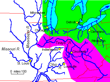 |
The Ohio River did not exist as such
before the last ice advances. A great buried river valley,
called the Teays River, probably was the principal east-west
drainage in the Midwest before then. The present Ohio
formed when ice blocked the Teays valley and river
headwaters flooded and linked across drainage divides. The Teays drainage basin is shown in purple. The ancestral Saint Lawrence drainage basin is shown in green. |
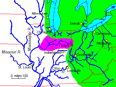 |
The Teays drainage itself looks like something assembled
by a committee, and it's reasonable to suppose that the Teays
drainage itself was the result of earlier ice diversions.
Here is one possible pre-Pleistocene drainage
configuration. The large river flowing northwest across Virginia and West Virginia is the ironically-named New River. Its upper portion was never diverted by ice and the river flows in a deep gorge. It is actually one of the oldest identifiable rivers in North America. |
If this interpretation is correct, it's entirely possible we would have a St. Lawrence drainage extending far down into the mid-Atlantic states. There would be no easy waterway joining Pennsylvania to the Gulf of Mexico. Access to the eastern interior would be much easier through Canada. It might well be possible to go all the way to Cincinnati.
Also, note that the ancestral Mississippi does not follow its present course but cuts through central Illinois. It assumed its present course when ice blocked the ancestral channel. In our alternate world, of course, that never happened. Furthermore, the bluffs along the Mississippi in Iowa, Wisconsin and Minnesota are very rugged and youthful looking. It is widely suspected that the upper Mississippi may have been diverted into its present course by a Nebraskan ice lobe. If that's the case, where did it flow before the Pleistocene? Since there's no conspicuous buried valley across Iowa and Minnesota, it wasn't there. A real possibility is that the pre-Pleistocene trunk drainage came down through the central Wisconsin lowland.
So instead of being the Father of Waters, our counterfactual Mississippi has no Missouri or Ohio flowing into it. It's a greatly reduced river system although still pretty significant.
Evolution of the Great Lakes
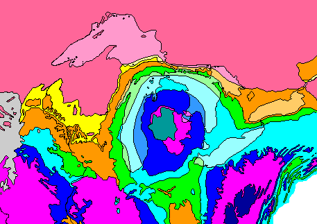 |
The Great Lakes are not random. They are where they are because of belts of hard and soft rocks. Late Ordovician rocks (orange) were scoured away by the glaciers to form Green Bay, Georgian Bay (which early explorers regarded as a separate lake), and the basin of Lake Ontario. Resistant Silurian rocks (green) form the Door Peninsula of Wisconsin, Manitoulin Island, the Bruce Peninsula, and the Niagara Escarpment. Devonian rocks (light blue) were scoured away to form the basins of Lake Michigan, Lake Huron, and Lake Erie. |
In our counterfactual world, the ice never gets far enough south or stays long enough to carve great lakes. Furthermore, with no serious long-term blockage, the St. Lawrence River follows its ancestral valley. There is no Niagara Falls. With no Great Lakes forming a water superhighway to the interior, there is no Erie Canal. There is no easy water connection between the iron ore of Lake Superior and the coal of Pennsylvania. There is no Chicago, Milwaukee, Cleveland or Toronto. Green Bay is just another inland city.
With no Great Lakes, no Ohio River, and no Missouri River, westward movement across North America would have been far more complicated, but north-south movement might have been far easier. It might have been a fairly easy portage from the St. Lawrence headwaters to the truncated Ohio River. Maybe somebody would eventually have built a canal joining the counterfactual Ohio and St. Lawrence Rivers. The French might have found it much easier to settle, occupy, and exploit the interior. And even if they finally did lose North America to the British, access to the interior would have been much easier from Canada. The Atlantic colonies might have been hemmed in, unable to expand to the west.
That is, if there was an England at all.
The English Channel
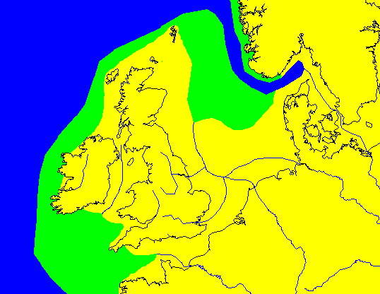 |
Before the Pleistocene, the British Isles were probably connected to the mainland. Submerged valleys hint at a former continuation of the Rhine out onto the North Sea shelf, with the Thames and probably the Elbe as tributaries. The Rhine is shown here flowing well north of its present outlet, which is surely the result of diversion. |
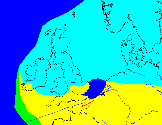 |
At ice maximum, only the far south of the British Isles was ice-free. The Rhine, blocked to the north, flooded its valley and found a new outlet. |
 |
Following the retreat of the ice, the sea floods the new valley, creating the English Channel. |
In our counterfactual world, the Scandinavian and British ice caps never quite merge, or never form a complete dam. Water drains to the Atlantic between the ice sheets or over them when they do connect.
Think of all the history that flows from Britain being an island - the defeat of the Spanish Armada, the opposition to Napoleon and Hitler - and none of it might have happened if the ice hadn't blocked the North Sea. Britain would be open to European invaders by land as well as sea.
The Romans would have found it much easier to invade Britain. After the fall of Rome, it's hard to imagine Britain not being invaded by Germanic tribes, but by land as well as by sea. On the other hand, the lack of an English Channel might have shielded France and Ireland from Viking invasion. Maybe there would still have been a fusion of English and French to give us something like English. The Spanish Armada could simply have landed troops in the Netherlands (then under Spanish control) and marched in. With a need to be a land power and defend a land frontier, England might not have developed its dominant navy and its unprecedented ability to project global power, and there might have been no British Empire. There's nobody to stop Napoleon. There's no Nelson's Column in Trafalgar Square, because there was no Nelson and no Trafalgar. There was nobody to stop Hitler.
And what of Ireland? If it had remained connected by land to Britain, could it still have served as a refuge for learning after the fall of Rome? Would it have been so easy to exploit Ireland as a base for intrigues against England, with all the tragic consequences? Would Ireland have even been strategically important at all, given the more pressing need to defend a long land frontier with France? Or might there have been more of an accommodation between the two societies? Would the Celts have been better able to resist invaders, or more vulnerable?
Coming to America
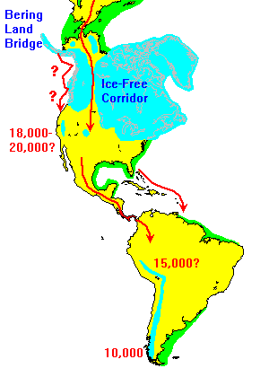 |
The most likely route for humans to enter
America was overland via the Bering land bridge. Some
anthropologists believe humans could not have gotten
further south until the clearing of the Ice-Free Corridor
about 12,000 years ago. However, the Corridor was never
extensively blocked by ice, and short ice blockages might
not have been a serious obstacle. Other anthropologists have suggested that immigrants could have traveled via the coast, hopping from one ice-free enclave to the next. Recently, even a trans-Atlantic route has been proposed, perhaps following the margins of pack ice in pursuit of seals. However, given the distances involved, that seems like a long shot. What about much earlier arrivals? It takes time for any species to expand its range, and there's just no evidence that humans got to Siberia or the Americas before at most 25,000 years ago. |
Given the time scale above (which some anthropologists reject as too old), humans could have reached Tierra del Fuego at a rate of only a kilometer or so a year. Even if humans didn't get into the U.S. until 12,000 years ago, they could have reached the tip of South America migrating only 5-6 kilometers a year.
Who killed the mammoths? The jury is still out. Megafaunas everywhere went extinct about the time humans arrived, but why hunt mammoths when buffalo, or even rabbits, are more abundant? The last mammoths, by the way, lived on Wrangel Island off Siberia and actually survived until about the time the Pyramids were being built.
In our counterfactual world, smaller ice caps might have drawn sea level down less, resulting in a smaller Bering Land Bridge. But even if there never was a land connection, it's hard to imagine such a narrow water gap remaining uncrossed for very long. The Ice Free Corridor would likely have been more open, but the overall impact on humans entering the Americas would have been minimal. As noted above, it takes time for any species to expand its range, and there's just no evidence that humans got to Siberia or the Americas before at most 25,000 years ago.
Return to 296-202 Visuals
Index
Access Slides of Glaciers
Return to Professor Dutch's Home Page
Created 20 January 1997; Last Update November 22, 1999
Not an official UW-Green Bay site